Services
Photography, Videography and Inspections with DroneScape
Basic
- Unlimited photos
- Trained commercial drone operator
- IAA Approval
- On site risk assessments
- Public liability Insurance
- Drone flight preparations and operations
Ultra
- Unlimited photos
- Unlimited video
- Editing and selecting of video and photos
- Trained commercial drone operator
- IAA Approval
- Risk Assessments
- Public liability Insurance
- Drone Flight preparations and operations
Premium
- Unlimited photos
- Unlimited video
- Post processing and editing of photographs and videos
- Ground footage
- IAA Approval
- Risk Assessments
- Public liability Insurance
- Drone Flight preparations and operations
- A bespoke solution
Examples of photo and video work


")


Surveying, Mapping and Orthomosiacs with DroneScape
Basic
- Orthomosaic
- Unlimited photographs/video
- IAA Approval
- Risk Assessments
- Public liability Insurance
- Drone Flight preparations and operations
- Safe pass for construction sites
Ultra
- Orthomosaics taken with the Phantom 4 RTK (Real Time Kinematics)
- Length and area calculations
- Pix4D report on data obtained
- Unlimited photographys/video
- IAA Approval
- Risk Assessments
- Public liability Insurance
- Drone Flight preparations and operations
- Safe pass for construction sites
Premium
- GNSS equipment and Phantom 4 RTK used to obtain an accuracy of up to 3cm
- Pix4D report on data obtained
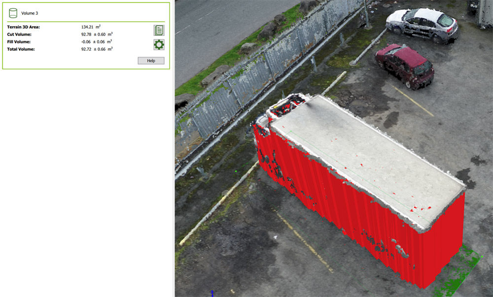
- 3D model (Digital surface model and Digital Terrain models)
- Volume calculations
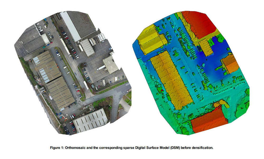
- Orthomosaics
- Unlimited photographs/video
- IAA Approval
- Risk Assessments
- Public liability Insurance
- Drone Flight preparations and operations
- Safe pass for construction sites
- A bespoke and custom solution
Accuracy
We pride ourselves on obtaining industry standard accuracy.
Our GSD (Ground sampling data) commonly achieves between 1-2cm per pixel. Industry acceptability is between 1 and 3 cm.
We use the DJI Phantom 4 RTK and geo-tag all our photographs to within positioning accuracy of vertical 1.5 cm + 1 ppm(RMS); Horizontal 1 cm + 1 ppm (RMS). This is done by connecting Phantom 4 RTK to GNSS (Global Navigation Satellite Systems) and the Irish RTK Network. NB: 1 ppm means the error has a 1mm increase for every 1 km of movement from the aircraft (This is based on DJI manufacturing specifications).
We also convert all our geo co-ordinates to ITM (Irish Transverse Mercator) or any other co-ordinate system you may require.
We use best practice to obtain accurate results. We know how to plan a flight for each project in order to achieve this level of accuracy.
A full quality report will be given to you so you can verify the accuracies of the data we have obtained.